
Plik:1945-05-01GerWW2BattlefrontAtlas.jpg
Rozmiar podglądu – 614 × 600 pikseli. Inne rozdzielczości: 246 × 240 pikseli | 491 × 480 pikseli | 786 × 768 pikseli | 1244 × 1215 pikseli.
Rozmiar pierwotny (1244 × 1215 pikseli, rozmiar pliku: 1,87 MB, typ MIME: image/jpeg)
| Plik 1945-05-01GerWW2BattlefrontAtlas.jpg znajduje się w Wikimedia Commons – repozytorium wolnych zasobów. Dane z jego strony opisu znajdują się poniżej. |
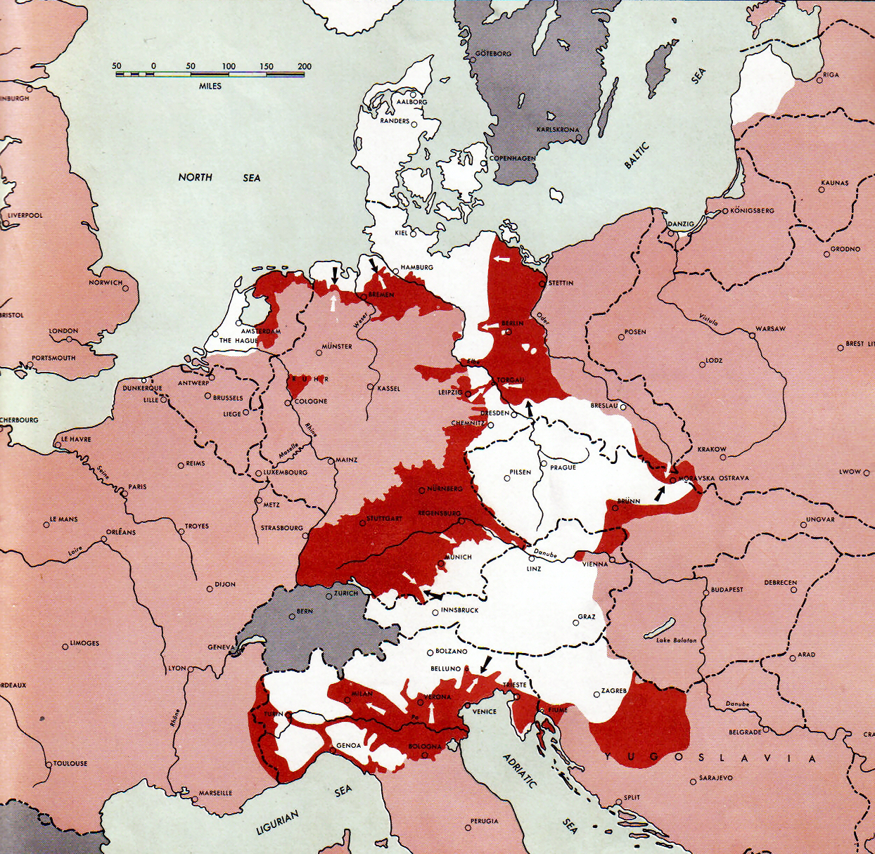
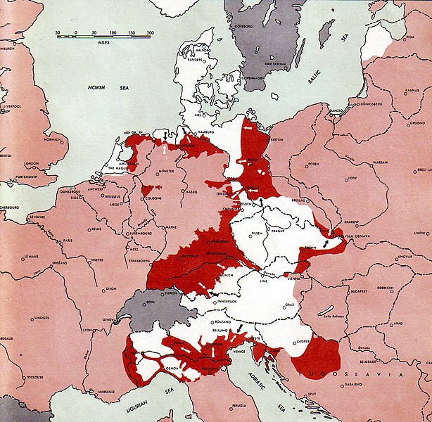
Atlas of the World Battle Fronts - War against Germany: 1945-05-01
← Previous map: 1945-04-15
→ Next map: 1945-05-15
Opis
| Opis |
Neutral nations (Sweden, Switzerland, Spain, etc.)
Under Allied control
Allied forces
Axis forces
  July 1, 1943 to June 30 1945 To the Secretary of War". (See Cover, Forward and Map details)  |
| Data | |
| Źródło | Document "Atlas of the World Battle Fronts in Semimonthly Phases to August 15th 1945: Supplement to The Biennial report of the Chief of Staff of the United States Army July 1, 1943 to June 30 1945 To the Secretary of War" |
| Autor | Army Map Service |
| Licencja (Ponowne użycie tego pliku) |
Public Domain: Work of US army |
Licencja
Ta grafika została utworzona przez pracownika lub żołnierza Armii Stanów Zjednoczonych podczas wykonywania czynności służbowych. Jako utwór Rządu Federalnego Stanów Zjednoczonych, grafika ta znajduje się w domenie publicznej.
|
 |
Historia pliku
Kliknij na datę/czas, aby zobaczyć, jak plik wyglądał w tym czasie.
| Data i czas | Miniatura | Wymiary | Użytkownik | Opis | |
|---|---|---|---|---|---|
| aktualny | 15:53, 10 wrz 2011 | | 1244 × 1215 (1,87 MB) | Finavon | Reverted to version as of 15:34, 6 November 2010 COM:USOP and en:MOS:IMAGES |
| 05:15, 10 wrz 2011 |  | 1274 × 1715 (1,82 MB) | Whoop whoop pull up | Reverted to version as of 23:50, 2 April 2011: Rv unexplained and unneeded crop. | |
| 13:30, 2 cze 2011 |  | 1244 × 1215 (1,87 MB) | DIREKTOR | ||
| 01:50, 3 kwi 2011 |  | 1274 × 1715 (1,82 MB) | Whoop whoop pull up | Reverted to version as of 20:15, 24 December 2007 The caption is very useful and practically all the other pictures in this series have retained them. | |
| 17:34, 6 lis 2010 |  | 1244 × 1215 (1,87 MB) | DIREKTOR | Crop | |
| 22:15, 24 gru 2007 |  | 1274 × 1715 (1,82 MB) | Mike Young | {{Information |Description= thumb|left|75pxthumb|right|75pxMap of the front against Germany: This map is taken from the source "Atlas of the World Battle Fronts in Semimonthly |
Lokalne wykorzystanie pliku
Poniższa strona korzysta z tego pliku:
Globalne wykorzystanie pliku
Ten plik jest wykorzystywany także w innych projektach wiki:
- Wykorzystanie na ar.wikipedia.org
- Wykorzystanie na az.wikipedia.org
- Wykorzystanie na be.wikipedia.org
- Wykorzystanie na bg.wikipedia.org
- Wykorzystanie na bs.wikipedia.org
- Wykorzystanie na ca.wikipedia.org
- Wykorzystanie na cs.wikipedia.org
- Wykorzystanie na da.wikipedia.org
- Wykorzystanie na de.wikipedia.org
- Wykorzystanie na el.wikipedia.org
- Wykorzystanie na en.wikipedia.org
- Battle of Berlin
- Italian campaign (World War II)
- Bleiburg repatriations
- Death of Adolf Hitler
- Flensburg Government
- Courland Pocket
- World War II in Yugoslavia
- Timeline of World War II (1945–1991)
- User:Eurocopter/Sandbox/Archive 1
- Wikipedia talk:Requests for mediation/Draza Mihailovic/Archive20
- Wikipedia:Reference desk/Archives/Humanities/2012 November 10
- User:Chickstarr404/Gather lists/12545 – "Exorcising Hitler"
- Wykorzystanie na en.wikisource.org
- Wykorzystanie na eo.wikipedia.org
- Wykorzystanie na es.wikipedia.org
- Wykorzystanie na et.wikipedia.org
- Wykorzystanie na fa.wikipedia.org
- Wykorzystanie na fi.wikipedia.org
- Wykorzystanie na fr.wikipedia.org
- Wykorzystanie na he.wikipedia.org
- Wykorzystanie na hr.wikipedia.org
- Wykorzystanie na hy.wikipedia.org
- Wykorzystanie na id.wikipedia.org
Pokaż listę globalnego wykorzystania tego pliku.