
Plik:AchaemenidMapBehistunInscription.png

Rozmiar podglądu – 800 × 511 pikseli. Inne rozdzielczości: 320 × 205 pikseli | 640 × 409 pikseli | 1020 × 652 pikseli.
Rozmiar pierwotny (1020 × 652 pikseli, rozmiar pliku: 17 KB, typ MIME: image/png)
| Plik AchaemenidMapBehistunInscription.png znajduje się w Wikimedia Commons – repozytorium wolnych zasobów. Dane z jego strony opisu znajdują się poniżej. |
Opis
| Opis |
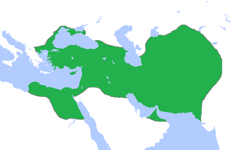
English: This a map of the Achaemenid Empire showing its greatest extent. I have given it more regions as listed on the Behistun Inscription the Persian King Darius wrote telling his conquests. |
| Data | |
| Źródło | http://en.wikipedia.org/wiki/File:Achemenids500BC.png |
| Autor | Gabagool |
| Licencja (Ponowne użycie tego pliku) |
http://en.wikipedia.org/wiki/File:Achemenids500BC.png |
- Other information
English: This is a map I have edited from that map and it says that I am free to share, to remix, but under the following conditions that i must the work in the manner specified by the author or licensor.
Ten plik udostępniony jest na licencji Creative Commons Uznanie autorstwa 1.0.
- Wolno:
- dzielić się – kopiować, rozpowszechniać, odtwarzać i wykonywać utwór
- modyfikować – tworzyć utwory zależne
- Na następujących warunkach:
- uznanie autorstwa – musisz określić autorstwo utworu, podać link do licencji, a także wskazać czy utwór został zmieniony. Możesz to zrobić w każdy rozsądny sposób, o ile nie będzie to sugerować, że licencjodawca popiera Ciebie lub Twoje użycie utworu.
Licencja
Ten plik udostępniony jest na licencji Creative Commons Uznanie autorstwa 3.0.
- Wolno:
- dzielić się – kopiować, rozpowszechniać, odtwarzać i wykonywać utwór
- modyfikować – tworzyć utwory zależne
- Na następujących warunkach:
- uznanie autorstwa – musisz określić autorstwo utworu, podać link do licencji, a także wskazać czy utwór został zmieniony. Możesz to zrobić w każdy rozsądny sposób, o ile nie będzie to sugerować, że licencjodawca popiera Ciebie lub Twoje użycie utworu.
Historia pliku
Kliknij na datę/czas, aby zobaczyć, jak plik wyglądał w tym czasie.
| Data i czas | Miniatura | Wymiary | Użytkownik | Opis | |
|---|---|---|---|---|---|
| aktualny | 02:53, 23 paź 2015 | | 1020 × 652 (17 KB) | LouisAragon | blocked sock. |
| 04:01, 13 paź 2015 |  | 1020 × 652 (22 KB) | History of Persia | My apologies sir but they did conquer parts of arabia. See the Achaemenid Arabia article. | |
| 03:50, 13 paź 2015 |  | 1020 × 652 (17 KB) | LouisAragon | Reverted to version as of 22:39, 6 February 2015 (UTC) | |
| 03:24, 13 paź 2015 |  | 1020 × 652 (22 KB) | LouisAragon | correct. | |
| 03:21, 13 paź 2015 |  | 1020 × 652 (22 KB) | LouisAragon | They simply did not conquer those territories you just added on all sides. | |
| 01:28, 9 wrz 2015 |  | 1012 × 648 (19 KB) | History of Persia | More accurate map. info on greek territories: File:Map Greco-Persian Wars-en.svg, size of Mascat (modern Oman/UAE): File:East-Hem 600bc.jpg. clay tablets in old persian have been found in bahrain, so its likely they were part of the achaemenid empire,... | |
| 02:48, 29 lip 2015 |  | 1020 × 652 (20 KB) | History of Persia | made achaemenid arabia better | |
| 02:25, 9 lip 2015 |  | 1020 × 652 (22 KB) | History of Persia | They had also conquered arabia-petrea (though it did not exist with that name) A wikipedia article of the province exists: Achaemenid Arabia | |
| 00:39, 7 lut 2015 |  | 1020 × 652 (17 KB) | HistoryofIran | I aprreciete your effort, but could you please upload the picture instead of replacing it with mine? thanks. | |
| 06:55, 29 sty 2015 |  | 1020 × 652 (59 KB) | Javierfv1212 | Updated the map by delineating the conquests of the three major Persian conqueror Kings, and also adding the names of the main satrapies of the empire. As a source I used this map of Ian Mladjov's Resources from the University of Michigan's History dep... |
Lokalne wykorzystanie pliku
Poniższa strona korzysta z tego pliku:
Globalne wykorzystanie pliku
Ten plik jest wykorzystywany także w innych projektach wiki:
- Wykorzystanie na ar.wikipedia.org
- Wykorzystanie na be.wikipedia.org
- Wykorzystanie na da.wikipedia.org
- Wykorzystanie na en.wikipedia.org
- Wykorzystanie na en.wikivoyage.org
- Wykorzystanie na eo.wikipedia.org
- Wykorzystanie na es.wikipedia.org
- Wykorzystanie na fa.wikipedia.org
- Wykorzystanie na fr.wikipedia.org
- Wykorzystanie na gl.wikipedia.org
- Wykorzystanie na hu.wikipedia.org
- Wykorzystanie na hy.wikipedia.org
- Wykorzystanie na id.wikibooks.org
- Wykorzystanie na incubator.wikimedia.org
- Wykorzystanie na it.wikipedia.org
- Wykorzystanie na it.wikiversity.org
- Wykorzystanie na ja.wikipedia.org
- Wykorzystanie na la.wikipedia.org
- Wykorzystanie na li.wikipedia.org
- Wykorzystanie na mg.wikipedia.org
- Wykorzystanie na ms.wikipedia.org
- Wykorzystanie na no.wikipedia.org
- Wykorzystanie na pnb.wikipedia.org
- Wykorzystanie na ps.wikipedia.org
- Wykorzystanie na ru.wikipedia.org
- Wykorzystanie na simple.wikipedia.org
- Wykorzystanie na sr.wikipedia.org
- Wykorzystanie na te.wikipedia.org
- Wykorzystanie na th.wikipedia.org
- Wykorzystanie na tr.wikipedia.org
- Wykorzystanie na tt.wikipedia.org
Pokaż listę globalnego wykorzystania tego pliku.