
Plik:First Irish farmers hut, Irish National Heritage Park - geograph.org.uk - 1252729.jpg
Grafika w wyższej rozdzielczości nie jest dostępna.
First_Irish_farmers_hut,_Irish_National_Heritage_Park_-_geograph.org.uk_-_1252729.jpg (640 × 480 pikseli, rozmiar pliku: 128 KB, typ MIME: image/jpeg)
| Plik First Irish farmers hut, Irish National Heritage Park - geograph.org.uk - 1252729.jpg znajduje się w Wikimedia Commons – repozytorium wolnych zasobów. Dane z jego strony opisu znajdują się poniżej. |
Opis
| Opis |
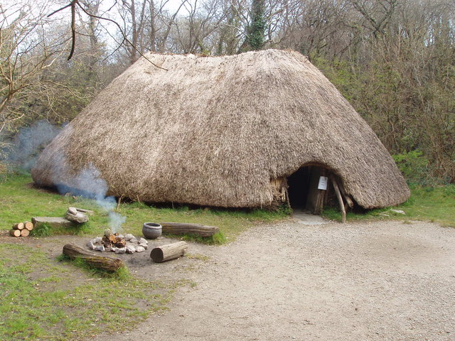
English: First Irish farmers hut, Irish National Heritage Park Around 4000 B.C. farmers came to Ireland and made permanent houses, raised livestock, grew cereals, and made pottery. In this exhibit in the Heritage Park a fire is lit on most days, some staff are in costumes of the various periods of Irish history, and on some days there are re-enactments of ancient life.
Première cabane d'agriculteurs irlandais. Le parc national du patrimoine irlandais vers 4000 avant J.-C., les agriculteurs sont venus en Irlande et ont construit des maisons permanentes, élevaient du bétail, ont planté des céréales, et faisaient de la poterie. Dans cette exposition dans le parc du patrimoine, un feu est allumé la plupart du temps, certains membres du personnel sont en costumes des différentes périodes de l'histoire irlandaise, et, certains jours, il y a des reconstitutions de la vie antique. |
| Data | |
| Źródło | From geograph.org.uk |
| Autor | David Hawgood |
| Uznanie autorstwa (wymagana przez licencję) | David Hawgood / First Irish farmers hut, Irish National Heritage Park / |
| Pozycja fotografa | | To i inne zdjęcia na: OpenStreetMap |
|---|
_heading:90.00&language=pl)
| Pozycja obiektu | | To i inne zdjęcia na: OpenStreetMap |
|---|
_heading:90.00&language=pl)
Licencja

|
Ta grafika pochodzi z kolekcji projektu Geograph. Aby zobaczyć szczegóły możesz odwiedzić stronę tego zdjęcia w serwisie Geograph. Prawa autorskie do tej grafiki posiada David Hawgood i jest ona udostępniona na licencji Creative Commons Uznanie autorstwa – Na tych samych warunkach 2.0.
|
Ten plik udostępniony jest na licencji Creative Commons Uznanie autorstwa – Na tych samych warunkach 2.0.
Uznanie autorstwa: David Hawgood
- Wolno:
- dzielić się – kopiować, rozpowszechniać, odtwarzać i wykonywać utwór
- modyfikować – tworzyć utwory zależne
- Na następujących warunkach:
- uznanie autorstwa – musisz określić autorstwo utworu, podać link do licencji, a także wskazać czy utwór został zmieniony. Możesz to zrobić w każdy rozsądny sposób, o ile nie będzie to sugerować, że licencjodawca popiera Ciebie lub Twoje użycie utworu.
- na tych samych warunkach – Jeśli zmienia się lub przekształca niniejszy utwór, lub tworzy inny na jego podstawie, można rozpowszechniać powstały w ten sposób nowy utwór tylko na podstawie tej samej lub podobnej licencji.
Historia pliku
Kliknij na datę/czas, aby zobaczyć, jak plik wyglądał w tym czasie.
| Data i czas | Miniatura | Wymiary | Użytkownik | Opis | |
|---|---|---|---|---|---|
| aktualny | 21:56, 26 lut 2011 | | 640 × 480 (128 KB) | GeographBot | == {{int:filedesc}} == {{Information |description={{en|1=First Irish farmers hut, Irish National Heritage Park Around 4000 B.C. farmers came to Ireland and made permanent houses, raised livestock, grew cereals, and made pottery. In this exhibit in the Her |
Lokalne wykorzystanie pliku
Poniższa strona korzysta z tego pliku:
Globalne wykorzystanie pliku
Ten plik jest wykorzystywany także w innych projektach wiki:
- Wykorzystanie na en.wikipedia.org
- Wykorzystanie na ga.wikipedia.org
- Wykorzystanie na lfn.wikipedia.org
- Wykorzystanie na nl.wikipedia.org
- Wykorzystanie na pt.wikipedia.org
- Wykorzystanie na sv.wikibooks.org