
Plik:Lizars Mexico & Guatimala 1831 UTA.jpg
Rozmiar pierwotny (6185 × 5238 pikseli, rozmiar pliku: 11,59 MB, typ MIME: image/jpeg)
| Plik Lizars Mexico & Guatimala 1831 UTA.jpg znajduje się w Wikimedia Commons – repozytorium wolnych zasobów. Dane z jego strony opisu znajdują się poniżej. |
Opis
| Tytuł |
English: Mexico & Guatimala [sic] |
||||||||||||||||||||||||||
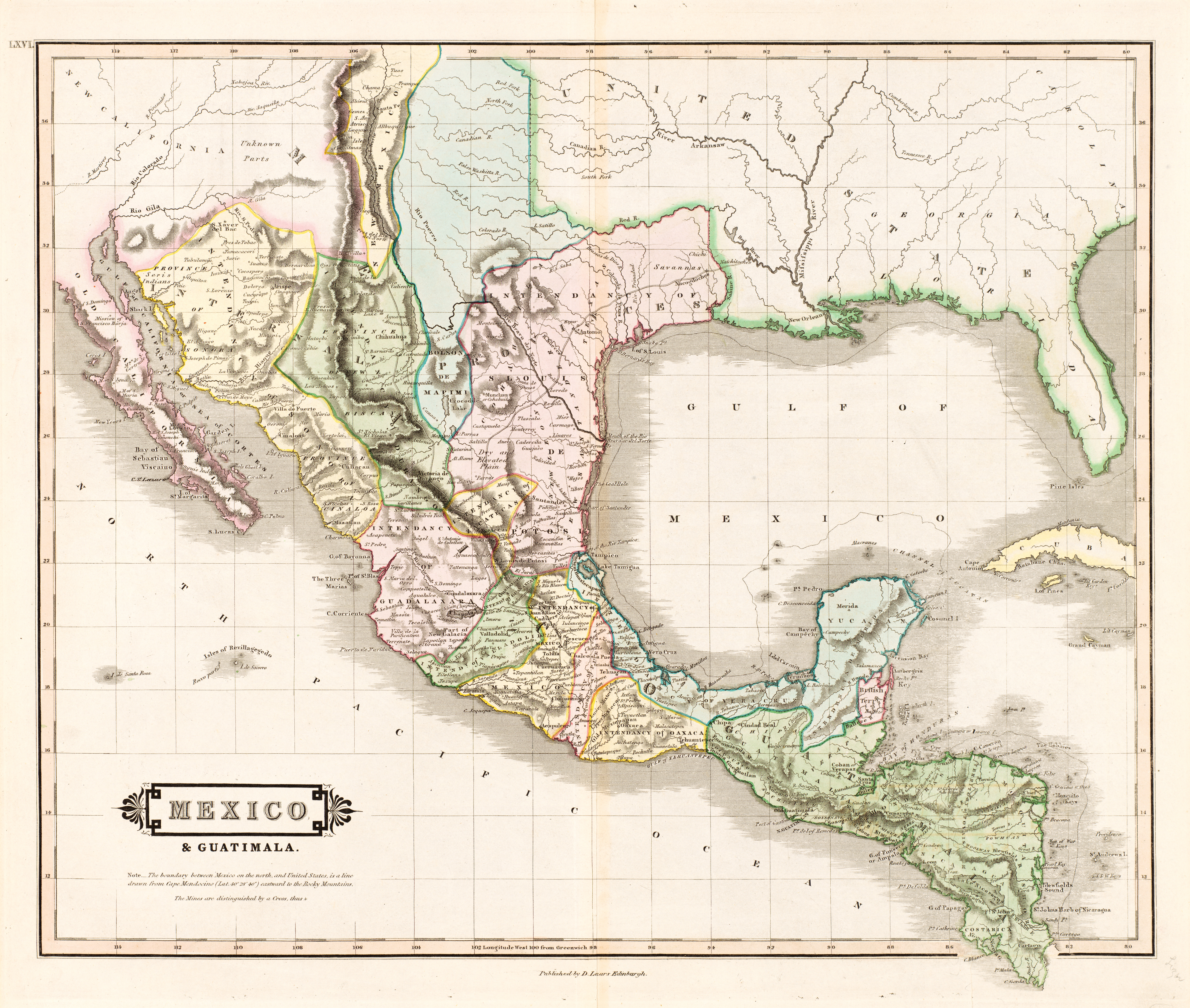
| Opis |
English: The creator of this map was probably Daniel Lizars II (1793-1875), the son of Edinburgh map engraver and publisher Daniel Lizars I (1754-1812) and younger brother of William Home Lizars (1788-1859). Shortly after producing the map, Daniel II went bankrupt in 1832 and emigrated to Canada in 1833. Lizars' map shows Mexico's administrative districts as Intendencies (Intendencias) and Internal Provinces (Provincias Internas) dating from the Spanish era. His depiction of the area that became Texas is notably jarring to modern viewers because his map further exaggerated some of the cartographic errors of his predecessors and contemporaries: particularly, a southerly "dip" of the middle Red River and the southerly courses of the Trinity, Brazos, and Colorado Rivers (which actually flow southeasterly). Settlements shown include Nacogdoches, "St." Antonio, and "Loredo". Interestingly, Lizars included the "British Territory" that became British Honduras or Belize. British logging settlements existed in the territory by the late eighteenth century and, although the British government had been hesitant to create a colony for fear of provoking the Spanish, settlers there were largely self-governing. |
||||||||||||||||||||||||||
| Data | około 1831 | ||||||||||||||||||||||||||
| Źródło | UTA Libraries Cartographic Connections: mapa / text | ||||||||||||||||||||||||||
| Twórca |
|
||||||||||||||||||||||||||
| Sposób pozyskania |
English: The University of Texas at Arlington Libraries Special Collections, Gift of Virginia Garrett |
||||||||||||||||||||||||||
| Dane geotemporalne | |||||||||||||||||||||||||||
| Map location |
Meksyk Gwatemala Teksas |
||||||||||||||||||||||||||
| Georeferencing | If inappropriate please set warp_status = skip to hide. | ||||||||||||||||||||||||||
| Dane bibliograficzne | |||||||||||||||||||||||||||
| Publikacja |
The Edinburgh Geographical and Historical Atlas |
||||||||||||||||||||||||||
| Autor |
John Hamilton |
||||||||||||||||||||||||||
| Miejsce wydania |
Edynburg Londyn Dublin |
||||||||||||||||||||||||||
| Wydawca |
John Hamilton Whittaker, Treacher & Co. W. Curry, Jun. & Co. |
||||||||||||||||||||||||||
| Dane archiwalne | |||||||||||||||||||||||||||
| Zbiór |
|
||||||||||||||||||||||||||
| Rozmiar | wysokość: 42 cm; szerokość: 51,5 cm | ||||||||||||||||||||||||||
| Medium | colored rycina na papierze | ||||||||||||||||||||||||||
| artwork-references |
Worms, Laurence; Ashley Baynton-Williams (2011) British Map Engravers, Londyn: Rare Book Society, ss. 406–409 |
||||||||||||||||||||||||||
| Inne wersje | |||||||||||||||||||||||||||
.jpg)
Licencja

|
This file was provided to Wikimedia Commons by the University of Texas at Arlington Libraries as part of a cooperation project. The University of Texas at Arlington Libraries is part of the University of Texas at Arlington, a public research university located in Arlington, Texas.
|
|
Autor tej pracy zmarł w 1875 roku, więc ten materiał przeszedł do domeny publicznej w kraju pochodzenia, jak również w państwach i terytoriach, gdzie prawo autorskie wygasa w ciągu 100 lat po śmierci autora. Powyższa praca jest własnością publiczną w Stanach Zjednoczonych, ponieważ została opublikowana (lub zarejestrowana w U.S. Copyright Office) przed 1 stycznia 1929. | |
| Plik rozpoznano jako wolny od znanych ograniczeń praw autorskich, włącznie z prawami zależnymi i pokrewnymi. | |
Historia pliku
Kliknij na datę/czas, aby zobaczyć, jak plik wyglądał w tym czasie.
| Data i czas | Miniatura | Wymiary | Użytkownik | Opis | |
|---|---|---|---|---|---|
| aktualny | 15:26, 13 lip 2019 | | 6185 × 5238 (11,59 MB) | Michael Barera | == {{int:filedesc}} == {{Map |title = ''Mexico & Guatimala'' [sic] |description = {{en|The creator of this map was probably Daniel Lizars II (1793-1875), the son of Edinburgh map engraver and publisher Daniel Lizars I (1754-1812) and younger brother of William Home Lizars (1788-1859). Shortly after producing the map, Daniel II went bankrupt in 1832 and emigrated to Canada in 1833. Lizars' map shows Mexico's administrative districts as Intendencies (''Intendencias'') and In... |
Lokalne wykorzystanie pliku
Żadna strona nie korzysta z tego pliku.
Globalne wykorzystanie pliku
Ten plik jest wykorzystywany także w innych projektach wiki:
- Wykorzystanie na en.wikipedia.org
- Wykorzystanie na es.wikipedia.org
- Wykorzystanie na hr.wikipedia.org
- Wykorzystanie na sh.wikipedia.org