
Plik:Orchard Park Municipal Center, Orchard Park, New York - 20201206.jpg

Rozmiar podglądu – 800 × 480 pikseli. Inne rozdzielczości: 320 × 192 pikseli | 1024 × 614 pikseli | 1280 × 768 pikseli | 2560 × 1536 pikseli | 4032 × 2419 pikseli.
Rozmiar pierwotny (4032 × 2419 pikseli, rozmiar pliku: 3,06 MB, typ MIME: image/jpeg)
| Plik Orchard Park Municipal Center, Orchard Park, New York - 20201206.jpg znajduje się w Wikimedia Commons – repozytorium wolnych zasobów. Dane z jego strony opisu znajdują się poniżej. |
Opis
| Opis |
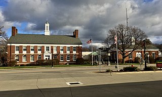
English: The Orchard Park Municipal Center, 4295 South Buffalo Street, Orchard Park, New York, December 2020. Respectively, the two wings of the building house the town and village offices (left) and the police department (right) and were built in 1949 as separate structures; an expansion in 1990 (center) served to connect the two and also added additional space in the rear. The original portions of the building, designed by the firm of Hudson & Hudson, exemplify the Colonial Revival style of architecture, which at that time retained a great deal of popularity in designs for government, school, and other institutional buildings, even as it had already passed out of favor in the arena of residential architecture. Both of the designs include classic Colonial hallmarks such as symmetrical façades and side-gabled roofs each with a central copper-topped cupola, but they differ from each other in the fine details. The more elaborate town hall portion sports a pedimented entrance, ornamental twin chimneys on the side elevations adjacent to the peak of the roof, and a contrast between the windows on the ground floor (round-arched and topped consecutively with fanlights and decorative keystones) and the second floor (rectangular and topped with stone lintels), with stone belt courses delineating the boundaries between floors. Meanwhile, the single-story and more modestly designed police station has a segmental-arched entrance with a golden eagle adorning the tympanum. |
| Data | Zdjęcie wykonano 6 grudnia 2020, 13:59:50 |
| Źródło | Praca własna |
| Autor | Andre Carrotflower |
| Pozycja fotografa | | To i inne zdjęcia na: OpenStreetMap |
|---|
Licencja
Ja, właściciel praw autorskich do tego dzieła, udostępniam je na poniższej licencji
Ten plik udostępniony jest na licencji Creative Commons Uznanie autorstwa – Na tych samych warunkach 4.0 Międzynarodowe.
- Wolno:
- dzielić się – kopiować, rozpowszechniać, odtwarzać i wykonywać utwór
- modyfikować – tworzyć utwory zależne
- Na następujących warunkach:
- uznanie autorstwa – musisz określić autorstwo utworu, podać link do licencji, a także wskazać czy utwór został zmieniony. Możesz to zrobić w każdy rozsądny sposób, o ile nie będzie to sugerować, że licencjodawca popiera Ciebie lub Twoje użycie utworu.
- na tych samych warunkach – Jeśli zmienia się lub przekształca niniejszy utwór, lub tworzy inny na jego podstawie, można rozpowszechniać powstały w ten sposób nowy utwór tylko na podstawie tej samej lub podobnej licencji.
Historia pliku
Kliknij na datę/czas, aby zobaczyć, jak plik wyglądał w tym czasie.
| Data i czas | Miniatura | Wymiary | Użytkownik | Opis | |
|---|---|---|---|---|---|
| aktualny | 02:43, 14 sty 2021 | | 4032 × 2419 (3,06 MB) | Andre Carrotflower | Uploaded own work with UploadWizard |
Lokalne wykorzystanie pliku
Poniższa strona korzysta z tego pliku:
Globalne wykorzystanie pliku
Ten plik jest wykorzystywany także w innych projektach wiki:
- Wykorzystanie na ar.wikipedia.org
- Wykorzystanie na ca.wikipedia.org
- Wykorzystanie na es.wikipedia.org
- Wykorzystanie na fr.wikipedia.org
- Wykorzystanie na uk.wikipedia.org
- Wykorzystanie na www.wikidata.org