
Plik:Valle Central de Costa Rica.jpg
Rozmiar pierwotny (1152 × 870 pikseli, rozmiar pliku: 197 KB, typ MIME: image/jpeg)
| Plik Valle Central de Costa Rica.jpg znajduje się w Wikimedia Commons – repozytorium wolnych zasobów. Dane z jego strony opisu znajdują się poniżej. |
Opis
| Opis |
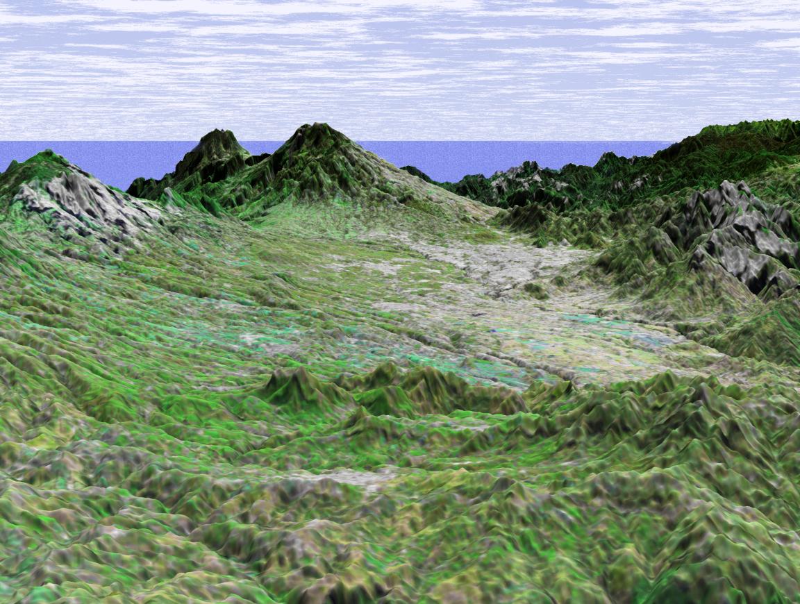
Español: Imagen de radar del Valle Central de Costa Rica grabada por la misión del transbordador espacial STS-99 de la NASA en 2000.
English: Radar image of the Central Valley of Costa Rica recorded by the NASA Space Shuttle mission STS-99 in 2000.
NASA image title: Shuttle Radar Topography Mission (SRTM) Perspective View with Landsat Overlay: San Jose, Costa Rica. NASA image description: This perspective view shows the capital city of San Jose, Costa Rica, in the right center of the image (gray area). Rising behind it are the volcanoes Irazu, 3402 meters high (11,161 feet) and Turrialba, 3330 meters high (10,925 feet.) Irazu is the highest volcano in Costa Rica and is located in the Irazu Volcano National Park, established in 1955. There have been at least 23 eruptions of Irazu since 1723, the most recent during 1963 to 1965. This activity sent tephra and secondary mudflows into cultivated areas, caused at least 40 deaths, and destroyed 400 houses and some factories. This image was generated in support of the Central American Commission for Environment and Development through an agreement with NASA. The Commission involves eight nations working to develop the Mesoamerican Biological Corridor, an effort to study and preserve some of the most biologically diverse regions of the planet. This three-dimensional perspective view was generated using topographic data from the Shuttle Radar Topography Mission (SRTM) and an enhanced false-color Landsat 7 satellite image. Colors are from Landsat bands 5, 4, and 2 as red, green and blue, respectively. Topographic expression is exaggerated 2X. Landsat has been providing visible and infrared views of the Earth since 1972. SRTM elevation data matches the 30-meter resolution of most Landsat images and will substantially help in analyses of the large and growing Landsat image archive. The Landsat 7 Thematic Mapper image used here was provided to the SRTM by the United States Geological Survey, Earth Resources Observation Systems (EROS) Data Center, Sioux Falls, South Dakota. Elevation data used in this image was acquired by the Shuttle Radar Topography Mission (SRTM) aboard the Space Shuttle Endeavour, launched on February 11, 2000. SRTM used the same radar instrument that comprised the Spaceborne Imaging Radar-C/X-Band Synthetic Aperture Radar (SIR-C/X-SAR) that flew twice on the Space Shuttle Endeavour in 1994. SRTM was designed to collect three-dimensional measurements of the Earth's surface. To collect the 3-D data, engineers added a 60-meter-long (200-foot) mast, installed additional C-band and X-band antennas, and improved tracking and navigation devices. The mission is a cooperative project between the National Aeronautics and Space Administration (NASA), the National Imagery and Mapping Agency (NIMA) of the U.S. Department of Defense (DoD), and the German and Italian space agencies. It is managed by NASA's Jet Propulsion Laboratory, Pasadena, CA, for NASA's Earth Science Enterprise,Washington, DC. Size: scale varies in this perspective image Location: 10.0 deg. North lat., 83.8 deg. East lon. Orientation: looking Southeast Image Data: Landsat Bands 5, 4, 3 as red, green, blue respectively Original Data Resolution: SRTM 30 meters (99 feet) Date Acquired: February, 2000 (SRTM) |
| Data | (date posted online) |
| Źródło | Shuttle Radar Topography Mission (SRTM) Perspective View with Landsat Overlay: San Jose, Costa Rica. |
| Autor | NASA/JPL/NIMA/USGS |
Ta grafika lub film został skatalagowany przez Johnson Space Center Stanów Zjednoczonych Ameryki National Aeronautics and Space Administration (NASA)pod Photo ID: PIA03316. Ten szablon nie wskazuje stanu prawnego pliku. Standardowy szablon licencji jest nadal wymagany. Aby dowiedzieć się więcej, zajrzyj na stronę Commons:Licencja. Inne języki:
|
Licencja
| Ten plik jest w domenie publicznej ponieważ został stworzony przez NASA. Polityka praw autorskich NASA stwierdza, że „materiały NASA nie są chronione prawami autorskimi, chyba że zapisano inaczej”. (NASA copyright policy lub JPL Image Use Policy). | ||
 |
Uwaga:
|
Historia pliku
Kliknij na datę/czas, aby zobaczyć, jak plik wyglądał w tym czasie.
| Data i czas | Miniatura | Wymiary | Użytkownik | Opis | |
|---|---|---|---|---|---|
| aktualny | 21:27, 13 maj 2021 | | 1152 × 870 (197 KB) | Spideog | Larger image, higher resolution |
| 05:43, 25 wrz 2005 |  | 600 × 453 (48 KB) | ArquiWHAT | Valle Central de Costa Rica tomado de http://visibleearth.nasa.gov/images/2045/PIA03316_md.jpg |
Lokalne wykorzystanie pliku
Żadna strona nie korzysta z tego pliku.
Globalne wykorzystanie pliku
Ten plik jest wykorzystywany także w innych projektach wiki:
- Wykorzystanie na es.wikipedia.org
- Wykorzystanie na lld.wikipedia.org
- Wykorzystanie na www.wikidata.org