
Plik:Yemen division 2011-10-23.svg

Wielkość pliku podglądu PNG dla pliku SVG: 800 × 522 pikseli Inne rozdzielczości: 320 × 209 pikseli | 640 × 418 pikseli | 1024 × 669 pikseli | 1280 × 836 pikseli | 2560 × 1671 pikseli | 1524 × 995 pikseli.
Rozmiar pierwotny (Plik SVG, nominalnie 1524 × 995 pikseli, rozmiar pliku: 1,07 MB)
| Plik Yemen division 2011-10-23.svg znajduje się w Wikimedia Commons – repozytorium wolnych zasobów. Dane z jego strony opisu znajdują się poniżej. |
Opis
| Opis |
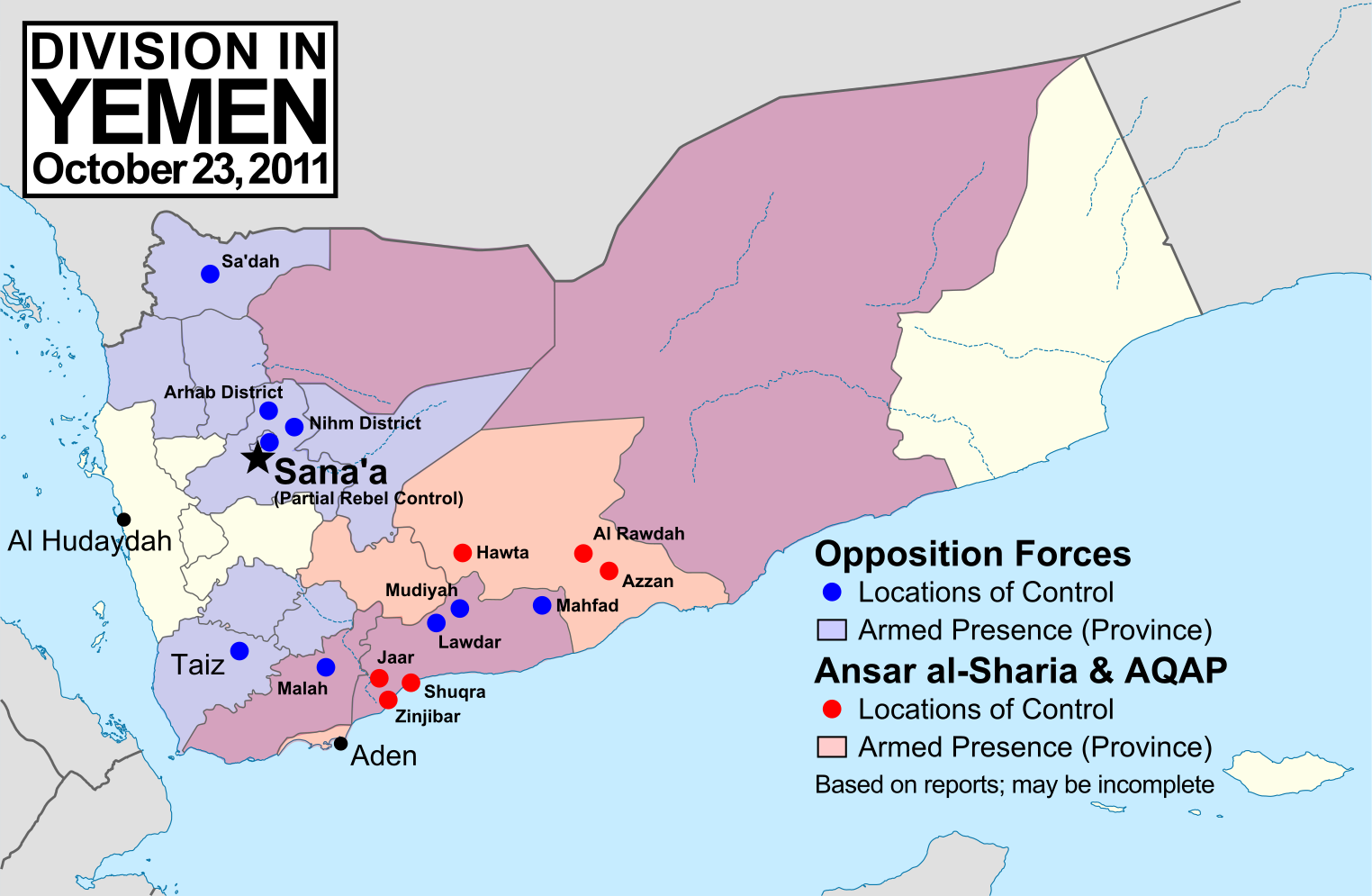
English: Note: This map depicts the situation in October 2011. For an updated version, see File:Yemen division 2012-3-11.svg. Map of division in Yemen as of October 23, 2011. Map is limited to information from English-language media, and therefore may be incomplete. Red represents Islamist extremists under Ansar al-Sharia and/or Al-Qaeda in the Arabian Peninsula (AQAP). Blue represents all other non-government armed groups which are hostile or possibly hostile to the government of President Ali Abdullah Saleh, including military defectors, pre-existing rebel groups, and local and kinship-based militias (including those which have worked together with the government against Ansar al-Sharia). Dots indicate specific locations cited by the media as being currently controlled by said groups, while shading indicates provinces (governorates) from which an open armed presence or attacks by said groups have been reported since the uprising began. Purple shading indicates that Ansar al-Sharia/AQAP and other non-government forces both have armed presences reported within the province, while white indicates that no rebel activity has been reported (implying that Saleh's government still fully maintains state power there). Note that unarmed protests are not depicted, and would extend well into the white areas of the map. See also: File:Yemen division 2011-7-7.svg |
| Data | |
| Źródło | Praca własna, starting from File:Yemen_location_map.svg by user NordNordWest. Information comes from a variety of online news sources, especially the Yemen Post and Critical Threats. |
| Autor | GeoEvan |
| Licencja (Ponowne użycie tego pliku) |
Modified version of file from Political Geography Now blog, re-licensed here to allow for commercial use. Please credit "Political Geography Now" with link to http://www.polgeonow.com. |
Licencja
Ja, właściciel praw autorskich do tego dzieła, udostępniam je na poniższej licencji
Ten plik udostępniony jest na licencji Creative Commons Uznanie autorstwa – Na tych samych warunkach 3.0.
- Wolno:
- dzielić się – kopiować, rozpowszechniać, odtwarzać i wykonywać utwór
- modyfikować – tworzyć utwory zależne
- Na następujących warunkach:
- uznanie autorstwa – musisz określić autorstwo utworu, podać link do licencji, a także wskazać czy utwór został zmieniony. Możesz to zrobić w każdy rozsądny sposób, o ile nie będzie to sugerować, że licencjodawca popiera Ciebie lub Twoje użycie utworu.
- na tych samych warunkach – Jeśli zmienia się lub przekształca niniejszy utwór, lub tworzy inny na jego podstawie, można rozpowszechniać powstały w ten sposób nowy utwór tylko na podstawie tej samej lub podobnej licencji.
Historia pliku
Kliknij na datę/czas, aby zobaczyć, jak plik wyglądał w tym czasie.
| Data i czas | Miniatura | Wymiary | Użytkownik | Opis | |
|---|---|---|---|---|---|
| aktualny | 17:15, 19 lis 2011 | | 1524 × 995 (1,07 MB) | GeoEvan | Corrections per English Wikipedia talk page (http://en.wikipedia.org/wiki/File_talk:Yemen_division_2011-10-23.svg): Added Sa'dah city to opposition controlled locations; changed "Islamist Militants" label to "Ansar a-Sharia & AQAP" so as to exclude the un |
| 21:41, 25 paź 2011 |  | 1524 × 995 (1,04 MB) | GeoEvan | =={{int:filedesc}}== {{Information |description={{en|1=Map of division in Yemen as of October 23, 2011. Map is limited to information from from English-language media, and therefore may be incomplete. Red represents Islamist militants (Ansar al-Sharia and |
Lokalne wykorzystanie pliku
Poniższa strona korzysta z tego pliku:
Globalne wykorzystanie pliku
Ten plik jest wykorzystywany także w innych projektach wiki:
- Wykorzystanie na azb.wikipedia.org
- Wykorzystanie na ca.wikipedia.org
- Wykorzystanie na en.wikipedia.org
- Wykorzystanie na hy.wikipedia.org
- Wykorzystanie na it.wikipedia.org
- Wykorzystanie na ka.wikipedia.org
- Wykorzystanie na pt.wikipedia.org
- Wykorzystanie na ru.wikipedia.org
- Wykorzystanie na www.wikidata.org