
Plik:Africa1898.png
Rozmiar pierwotny (2490 × 3563 pikseli, rozmiar pliku: 4,14 MB, typ MIME: image/png)
| Plik Africa1898.png znajduje się w Wikimedia Commons – repozytorium wolnych zasobów. Dane z jego strony opisu znajdują się poniżej. |
Opis
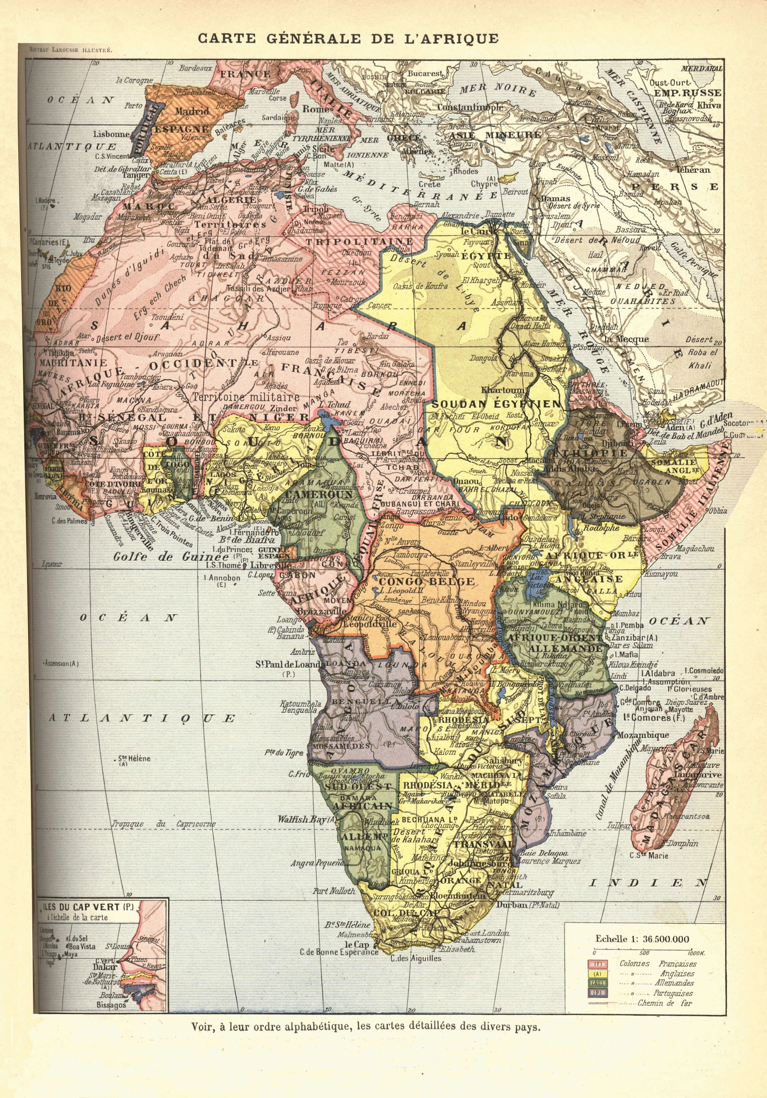
French map of Africa from 1912? [text in comment below says 1898], originally published as "Carte Générale de l'Afrique : Voir, à leur ordre alphabétique, les cartes detaillées des divers pays" in Nouveau Larousse illustré ; dictionnaire universel encyclopédique, publié sous la direction de Claude Augé. Paris, Librairie Larousse. 1898-1904. Original scan available at http://www.lib.msu.edu/coll/main/maps/mapscan/AFthumbs.html
Colonial claims:
- British possessions are in yellow
- French possessions in pink
- Belgian in orange
- German in green
- Portuguese in purple
- Italian in striped pink
- Spanish in striped orange
- independent Ethiopia in brown
Note:
This map is depicts various anachronisms and despite the stated publication date above (different editions?) of its work, was drawn between 1911 and 1914:
- en:Belgian Congo includes the en:Lado enclave, which was ceded to Anglo-Sudan in 1910.
- Occupation of Libya by Italy started in 1911, and the colony was established in 1912.
- "Cameroun" is depicted with the territory of German en:Neukamerun, ceded from France 1911.
Licencja
|
Ten materiał przeszedł do domeny publicznej w kraju pochodzenia, jak również w państwach i terytoriach, gdzie prawo autorskie wygasa w ciągu 70 lat po śmierci autora.
| |
| Plik rozpoznano jako wolny od znanych ograniczeń praw autorskich, włącznie z prawami zależnymi i pokrewnymi. | |
Historia pliku
Kliknij na datę/czas, aby zobaczyć, jak plik wyglądał w tym czasie.
| Data i czas | Miniatura | Wymiary | Użytkownik | Opis | |
|---|---|---|---|---|---|
| aktualny | 18:27, 16 lip 2009 | | 2490 × 3563 (4,14 MB) | Jonverve~commonswiki | update - rotate and fix |
| 21:49, 11 maj 2006 |  | 962 × 1314 (915 KB) | Kmusser | French map of Africa from 1898, originally published as "Carte Generale de l'Afrique: Voir, a leur orde alphabetique, les cartes detaillees des divers pays" in Nouveau Larousse illustré; dictionnaire universel encyclopédique, publié sous la direction d |
Lokalne wykorzystanie pliku
Następujące strony korzystają z tego pliku:
Globalne wykorzystanie pliku
Ten plik jest wykorzystywany także w innych projektach wiki:
- Wykorzystanie na ast.wikipedia.org
- Wykorzystanie na az.wikipedia.org
- Wykorzystanie na ba.wikipedia.org
- Wykorzystanie na be.wikipedia.org
- Wykorzystanie na bg.wikipedia.org
- Wykorzystanie na da.wikipedia.org
- Wykorzystanie na en.wikiversity.org
- Wykorzystanie na es.wikipedia.org
- Wykorzystanie na fr.wikipedia.org
- Wykorzystanie na he.wikipedia.org
- Wykorzystanie na hu.wikipedia.org
- Wykorzystanie na hy.wikipedia.org
- Wykorzystanie na is.wikipedia.org
- Wykorzystanie na it.wikipedia.org
- Wykorzystanie na ja.wikipedia.org
- Wykorzystanie na mk.wikipedia.org
- Wykorzystanie na mwl.wikipedia.org
- Wykorzystanie na nl.wikipedia.org
- Wykorzystanie na oc.wikipedia.org
- Wykorzystanie na pt.wikipedia.org
- História da África
- História da Guiné-Bissau
- História da Libéria
- História da Nigéria
- História do Congo
- História de Burquina Fasso
- História de Moçambique
- História da Etiópia
- História do Gabão
- História da Líbia
- História de Marrocos
- História do Quênia
- História do Gana
- História da África do Sul
- História da Costa do Marfim
- História da Tunísia
- História do Sudão
- História do Ruanda
- História do Togo
- História de Cabo Verde
- História de Angola
- História da Serra Leoa
Pokaż listę globalnego wykorzystania tego pliku.