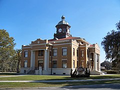
Hrabstwo Citrus
Na mapach: 28°51′00″N 82°31′12″W/28,850000 -82,520000
| hrabstwo | |

| |
| Państwo | |
|---|---|
| Stan | |
| Siedziba | |
| Kod statystyczny |
FIPS 6-4: 12017 |
| Powierzchnia |
2002,45 km²[1] |
| Populacja (2009) • liczba ludności |
|
Położenie na mapie Floryda
| |
| 28°51′00″N 82°31′12″W/28,850000 -82,520000 | |
| Strona internetowa | |
Hrabstwo Citrus (ang. Citrus County) – hrabstwo w stanie Floryda w Stanach Zjednoczonych. Obszar całkowity hrabstwa obejmuje powierzchnię 773,15 mil² (2002,45 km²). Według szacunków United States Census Bureau w roku 2009 miało 140 357 mieszkańców[2].
Hrabstwo powstało w 1887 roku[3]. Na jego terenie znajdują się obszary niemunicypalne: Beverly Hills, Citrus Hills, Citrus Springs, Floral City, Hernando, Holder, Homosassa, Homosassa Springs, Lecanto, Pine Ridge[4].
| Populacja hrabstwa w poprzednich latach[3] | |
|---|---|
| Rok | Liczba ludności |
| 1980 | 53 146 |
| 1990 | 93 515 |
| 2000 | 118 085 |
| 2005 | 134 370 |
Miejscowości[edytuj | edytuj kod]
CDP[edytuj | edytuj kod]
- Beverly Hills
- Black Diamond
- Citrus Springs
- Citrus Hills
- Floral City
- Hernando
- Homosassa
- Homosassa Springs
- Inverness Highlands North
- Inverness Highlands South
- Lecanto
- Pine Ridge
- Sugarmill Woods
Przypisy[edytuj | edytuj kod]
- ↑ US Census Bureau: Florida County. Population, Housing Units, Area, and Density: 2000. [dostęp 2011-05-04]. (ang.).
- ↑ a b US Census Bureau: Citrus County. Quickfacts. [dostęp 2011-05-04]. (ang.).
- ↑ a b National Association of Counties: Citrus County, FL. [dostęp 2011-05-04]. (ang.).
- ↑ National Association of Counties: Places in Citrus County, FL. [dostęp 2011-05-04]. (ang.).
Kontrola autorytatywna (hrabstwo w stanie Floryda):

