Hrabstwo Monterey
Na mapach: 36°14′24″N 121°18′36″W/36,240000 -121,310000
| hrabstwo | |||
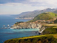
 widok na Big Sur | |||
| |||
| Państwo | |||
|---|---|---|---|
| Stan | |||
| Siedziba | |||
| Kod statystyczny |
FIPS 6-4: 06053 | ||
| Powierzchnia |
9767,03 km²[1] | ||
| Populacja (2009) • liczba ludności |
| ||
Położenie na mapie Kalifornia
| |||
| 36°14′24″N 121°18′36″W/36,240000 -121,310000 | |||
| Strona internetowa | |||
Hrabstwo Monterey (ang. Monterey County) – hrabstwo w stanie Kalifornia w Stanach Zjednoczonych. Obszar całkowity hrabstwa obejmuje powierzchnię 3771,07 mil² (9767,03 km²). Według szacunków United States Census Bureau w roku 2009 miało 410 370 mieszkańców[2].
Hrabstwo powstało w 1850 roku[3].
Na jego terenie znajdują się[4]:
- miejscowości – Carmel-by-the-Sea, Del Rey Oaks, Gonzales, Greenfield, King City, Marina, Monterey, Pacific Grove, Salinas, Sand City, Seaside, Soledad,
- CDP – Boronda, Bradley, Carmel Valley Village, Castroville, Chualar, Del Monte Forest, Elkhorn, Las Lomas, Lockwood, Moss Landing, Pajaro, Pine Canyon, Prunedale, San Ardo, San Lucas, Spreckels.
Przypisy[edytuj | edytuj kod]
- ↑ US Census Bureau: Population, Housing Units, Area, and Density: 2000. [dostęp 2012-11-13]. [zarchiwizowane z tego adresu (2015-07-08)]. (ang.).
- ↑ a b US Census Bureau: Monterey County. Quickfacts. [dostęp 2011-01-23]. (ang.).
- ↑ Monterey County, CA. [dostęp 2011-01-23 autor = National Association of Counties]. (ang.).
- ↑ National Association of Counties: Places in Monterey County, CA. [dostęp 2011-01-23]. (ang.).
Kontrola autorytatywna (hrabstwo w stanie Kalifornia):


