
Plik:1820 Виленская Губерния.jpg

Rozmiar pierwotny (4908 × 4739 pikseli, rozmiar pliku: 20,13 MB, typ MIME: image/jpeg)
| Plik 1820 Виленская Губерния.jpg znajduje się w Wikimedia Commons – repozytorium wolnych zasobów. Dane z jego strony opisu znajdują się poniżej. |
Opis
| Opis |
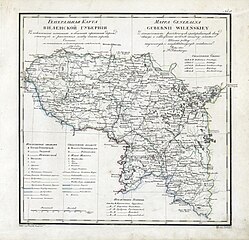
English: Geographic atlas of the Russian Empire, Kingdom of Poland and Grand Duchy of Finland is located in governorates in the Russian and French. 1821.
Русский: Географический атлас Российской империи, Царства Польского и Великого княжества Финляндского расположенный по губерниям на русском и французском языках. 1821 год. Виленская Губерния. Генеральная карта.
Français : Atlas Geografique de L Empire de Russie, du Royaume de Pologne et du Grand Duche de Finlande divise en Gouvernemens. Mappa Generalna Gubernii Wilenskiey. 1821. |
| Data | |
| Źródło | http://rutracker.org/forum/viewtopic.php?t=600838 |
| Autor | Пядышев, Военно-Картографическое Депо |
Licencja
|
Ten materiał przeszedł do domeny publicznej w kraju pochodzenia, jak również w państwach i terytoriach, gdzie prawo autorskie wygasa w ciągu 70 lat po śmierci autora.
| |
| Plik rozpoznano jako wolny od znanych ograniczeń praw autorskich, włącznie z prawami zależnymi i pokrewnymi. | |
Historia pliku
Kliknij na datę/czas, aby zobaczyć, jak plik wyglądał w tym czasie.
| Data i czas | Miniatura | Wymiary | Użytkownik | Opis | |
|---|---|---|---|---|---|
| aktualny | 11:53, 28 mar 2009 | | 4908 × 4739 (20,13 MB) | Berillium | {{Information |Description={{en|1=Geographic atlas of the Russian Empire, Kingdom of Poland and Grand Duchy of Finland is located in governorates in the Russian and French. 1821.}} {{ru|1=Географический атлас Российской имп |
Lokalne wykorzystanie pliku
Następujące strony korzystają z tego pliku:
Globalne wykorzystanie pliku
Ten plik jest wykorzystywany także w innych projektach wiki:
- Wykorzystanie na be.wikipedia.org
- Wykorzystanie na et.wikipedia.org
- Wykorzystanie na fi.wikipedia.org
- Wykorzystanie na he.wikipedia.org
- Wykorzystanie na lt.wikipedia.org
- Wykorzystanie na lt.wikibooks.org
- Wykorzystanie na lv.wikipedia.org
- Wykorzystanie na ru.wikipedia.org