Metropolitan Borough of Wirral
Na mapach: 53°23′49″N 3°00′43″W/53,396972 -3,011914
| dystrykt metropolitalny | |||
 Siedziba władz dystryktu | |||
| |||
| Państwo | |||
|---|---|---|---|
| Kraj | |||
| Region | |||
| Hrabstwo | |||
| Siedziba | |||
| Powierzchnia |
157 km² | ||
| Populacja (2016) • liczba ludności |
| ||
| • gęstość |
2046 os./km² | ||
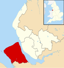
Położenie na mapie Merseyside
| |||
| Strona internetowa | |||
Metropolitan Borough of Wirral – dystrykt metropolitalny w hrabstwie ceremonialnym Merseyside w Anglii.
Miasta[edytuj | edytuj kod]
Inne miejscowości[edytuj | edytuj kod]
Barnston, Bidston, Brimstage, Bromborough, Caldy, Clatterbridge, Claughton, Eastham, Egremont, Frankby, Gayton, Grange, Greasby, Irby, Landican, Larton, Leasowe, Liscard, Meols, Moreton, New Brighton, New Ferry, Newton, Noctorum, Oxton, Pensby, Port Sunlight, Poulton, Prenton, Raby Mere, Raby, Rock Ferry, Saughall Massie, Seacombe, Spital, Storeton, Thingwall, Thornton Hough, Thurstaston, Tranmere, Upton, Wallasey Village, West Kirby, Woodchurch, Woodside.
Przypisy[edytuj | edytuj kod]
- ↑ Population Estimates for UK, England and Wales, Scotland and Northern Ireland - Office for National Statistics [online], www.ons.gov.uk [dostęp 2017-10-21] (ang.).

